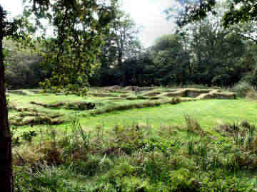
Penhallam - ruins of a very early Moated Manor House
This is both a remarkable and a confusing place. Start with confusing. Managers English Heritage call it Penhallam, but a farm a mile away is called Penhallym. Cornwall's Archaeological Heritage calls it Berry Court while the house next to the site is called Bury Court. And, just to add to the confusion, if you use the 1997 OS explorer map you will end up at Penhallym. I think the 2005 version may have it correctly located.
Now for the remarkable. First its discovery. Abandoned since the late 14th century, robbed of much of its stone for farm buildings, Penhallam was only rediscovered in the 1960s when forestry workers were clearing land for planting. It is in the care of English Heritage, bane of a particular kind of vandalistic Cornish nationalist who likes to deface its signs. Why do they not join Cornwall Heritage Trust and help care for these important sites?
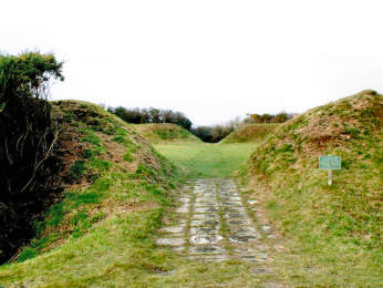
Almost more remarkable is that there is no other similar site in Cornwall - and its age. Begun around 1180 by Richard fitz Turold, it became by descent a home of the de Cardinham family. Moated on three sides, it was steadily extended by them to become four ranges around a central courtyard, with a drawbridge over the moat. The de Cardinhams finally abandoned this home sometime in the late 14th century. When I saw Penhallam in September 2006 the moat was dry after a long hot summer.
Penhallam - four ranges surround a central courtyard
Car park on Newmill - Week St. Mary road. 15 minute walk.
More in Antiquities
Piran Round near Perranporth
There are a hundred or more of these 'rounds' in Cornwall. Popular belief is convinced that they are 'plen-a-gwary' or 'playing places', amphitheatres created to stage the Cornish Ordinalia, early medieval Christian 'miracle plays'. Indeed, the Ordinalia was performed in these rounds, which made perfect amphitheatres, but most predate the Ordinalia by around 1000 years or more. At least the majority are the remains of iron-age fortified farmsteads. Piran (or Perran) Round, at the village of Rose near Perranporth, is an obvious example; 130 feet in diameter, its banks some 12 feet high, with a 6 foot ditch on the outside of the banks, and two entrances, it was clearly defensive. The St. Piran Project has begun clearing away scrub and weeds. An odd depression near the centre, two bowls joined by a straight channel, was probably made for one of the many activities that have taken place here - the plays, wrestling matches, village picnics, fetes and even the Cornish Gorsedd of Bards. Indeed in 1969 the Drama Department of Bristol University staged the Ordinalia here. A couple of miles north, in the sand dunes known as Penhale Sands, are the site of St. Piran's Oratory and a later church dedicated to him.
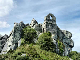
Roche Rock
On the north-western edge of the china clay fields just to the north of St. Austell, and just south of the unprepossessing village of Roche, is a granite outcrop about 100 feet high. Built into it is a granite tower. This is said to have been the hermitage of one Ogrin who gave shelter to the lovers Tristan and Isolde, escaping the wrath of the latter's husband King Mark. Unfortunately for the legend, the tower was built 900 years too late, in 1409, though in style it seems to be romanesque from a period a couple of hundred years earlier than that. A footpath leads up to the rock from the Roche to Bugle road. Look to the south and you will see the vast china clay spoil heaps. An iron age hill fort, just off the road from Lostwithiel to Fowey, and known as Castle Dore, is the legendary site of King Mark's castle. His nephew Tristan, was the lover of Yseult (Isolde), the Irish princess married to Mark. A stone inscribed in Latin, once near Castle Dore, reads in translation "here lies Drustanus (Tristan) son (?) of (Marcus) Cunomorus". The stone once stood by Castle Dore, was moved to the former east lodge of Menabilly and now stands by the roadside nearer Fowey. Menabilly has Daphne du Maurier associations, appearing in 'Rebecca' as Manderley.
Sancreed Beacon
I had no idea this existed until I spotted a long car park, just a little west of Sancreed church. Wondering what it was for, I investigated and found an information board telling me that high on the hill were bronze age remains. The site is rather over-run with heather and bracken so it is difficult to know exactly what you are seeing. There appeared to me to be just one massive barrow with two or three possible burial chambers exposed on top. Quite an oddity. Elsewhere is said to be remains of a bronze age hut but I couldn't find it. Views are great from up here, as so often on the high ground in West Penwith, on this occasion taking in St. Michael's Mount, Lizard Point and the ruined engine house at Ding Dong mine. Quite apart from this site, there is a lot more of interest to the antiquarian in the immediate area. A round walk of no more than five miles could include Carn Euny iron age village, Brane chambered cairn, Caer Bran hill fort and the small village of Sancreed. Sancreed has a charming church with several Conish crosses and a nearby holy well. Extend the walk by a couple of miles and you could also include St. Euny's holy well and the massive cairn on Chapel Carn Brea.