
Tregony
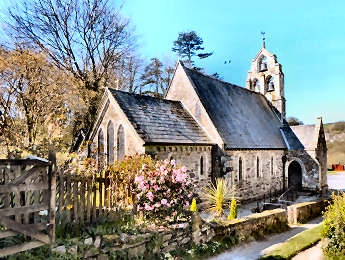
Tregony is a less than 10 miles from Truro but a world apart. Rather like Grampound it is virtually a one-street village and is on a hill. However, its hill is a great deal steeper than Grampound's, climbing altogether about 200 feet in its half-mile length from the River Fal at the bottom to St. Cuby's Church and the Primary School at the top. At one time the River Fal was navigable all the way up to Tregony, 15 miles from the sea. In those times it was an important port. In the early 17th century King James I gave Tregony free borough status and it was entitled to return two elected representatives to Westminster; no longer of course. Tregony lost its importance thanks essentially to the silting up of the River Fal, due primarily to run off from the chia clay pits and tin mines It is however a delightful village; or is it a small town? It certainly has some of the attributes: Anglican church, Methodist chapel, post office, shop, primary school, and pub, the excellent Kings Arms. Fore Street is lined with attractive cottages, looking 18th century, and there are a few Victorian villas. Notable features include the clock tower, the small square with its parish water pump, and its galleried almshouses, pictured left. These were built in 1896 by M.P. Hugh Boscawen and greatly restored in 1995. Their purpose was "to house poor housekeepers, who must be over sixty and have lived in a 2 mile radius of Tregony for 2 years".
Tregony's late 17th century almshouses
Signed off A390 St. Austell - Truro, between Probus & Tresillian
More in Towns & Villages
Tresillian
We drive through Tresillian every time we visit Truro or points west of there. As you approach from the east (our direction) what you see as you enter Tresillian, and prepare to turn sharp right across a bridge over the Tresillian River, is the formal, and normally unused, gates to the northern end of a four mile drive to Tregothnan, ancestral home of the Boscawens, Lords Falmouth. The village straggles along the main road. Along the way is the attractive Wheel Inn and some motor deakers on the left, a former toll house and an old maltings on the right. At the Truro end of the villlage a signed footpath takes you through a small marshy area and on to a firm path which follows the west side of the Tresillian River. The river itself, leading to attractive St. Clement is tidal; at low tide it is almost entirely mud. In spring daffodils line the south side of the road. Before you turn right over the river on the main road, to your left is the Anglican church, dull from the front but attractive from up the track alongside it. To my surprise, a Cornish Cross sits on the kerbside in front of the church. The Victorian church was firmly locked when I was there; I doubt if I missed much, Pevsner is not exactly complimentary. The lane alongside the church leads to St. Michael Penkevil and Tregothnan.
Treslothan
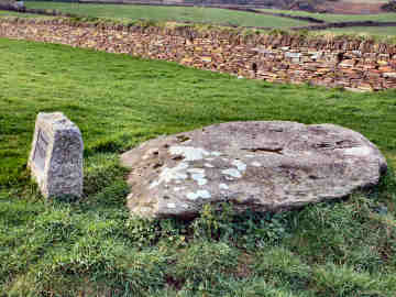
When I walked from Beacon to Clowance on the Land's End Trail, I was really surprised by Treslothan hamlet. All very grey and Victorian gothic but all most beautifully maintained. This was the estate village of nearby Pendarves House and survived intact when the Georgian home of the Pendarves family was demolished in 1955. All built in the 1840s by architect George Whitwick, the church, houses and former school are all of the same silvery grey granite and surround a war memorial. Contrast the number of names on the memorial with the smallness of the village; these must all have been workers on the large but dispersed Pendarves estate. Next to the church is the Pendarves Mausoleum. Buried in the churchyard is self-taught Camborne born poet John Harris. On a corner by woods is the former village well. From here a footpath heads roughly south, first passing the former village school, now a private home, then continuing through fields and woods to the road from Troon to Carwynnen. If you are visiting Carwynnen Quoit, re-erected in 2014 by the Sustainable Trust, this is as good a route to take as any, turning right on the road towards Carwynnen for a short distance, then right through a gate into a field. Immediately inside the gate is a good storyboard; the quoit is across the field.
Trethevey and Trevalga
A walk from Boscastle in January 2008 took in Trevalga hamlet, Trethevy village, St. Nectan's Glen and Forrabury church. Trethevey I remember from my early days of touring when I, unsurprisingly, looked unavailingly for Trethevy Quoit there. So imagine my surprise when I found at the roadside 'King Arthur's Quoit', a massive flat rock said to have been hurled there by Arthur from Tintagel Castle but possibly once the capstone of a real qouit. In the village on the other side of the road I was pleased to find St. Piran's Chapel and Well but failed to find the Roman milestone. Trevalga I researched after hearing from a German who holidays in Cornwall. A charming hamlet, its last Lord of the Manor, Gerald Curgenven, left it in 1959 to a trust managed by his old school, Marlborough College. It's six farms are now just two and its important buildings are away from the hamlet - the Manor House on the cliffs, the Rectory half-a-mile inland. My walk included the following: Forrabury church is of little interest, except for its font and Cornish cross, but leave the north-west corner of the churchyard and you are on Forrabury Stitches, a medieval field system maintained by the National Trust. Forget about St. Nectan's Glen, it is gloomy and the owners of The Hermitage want �3.50 (2008) to see the famous waterfall!