Lanteglos-by-Camelford - Castle Goff and St. Julitta's Well
Having passed close by, on the Camel Ramblers November 2008 AGM Day walk, in dull and wet conditions, I took the opportunity of a fine day soon after to return to Lanteglos to take a look at Castle Goff and also to seek out St. Julitta's holy well. Until 2004 the site would have been inacessible on Castlegoff Farm land but was cleared and is now managed under the Countryside Stewardship scheme. There is easy access on foot from Lanteglos village. Tha name Castle Goff is strange. It is thought to mean (the) smith's castle. Why? Was it a metal working site at one time? It is described as an iron age hill fort but, surely, was no more than a fortified farmstead. In addition to the 80 yard diameter circle of bank and ditch, there are traces of a western extension. Just quarter of a mile to the north-west is another ancient site, shown as 'settlement' on OS109. It's circular and several times the area of Castle Goff. A more recent track cuts across it. St. Julitta's Holy Well is in the grounds of Juliot's Well Holiday Park. Julitta was one of the many saintly offspring of the fecund Welsh King Brychan. To find the well just follow the drive till it becomes a green lane downhill. At the bottom, head left to near the second pond. You will find it there under a tree.
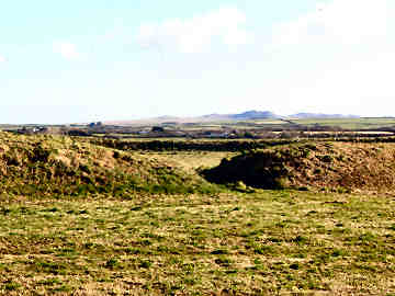
Castle Goff is on OS Explorer map 106 at Grid Ref 084/827
Castle Goff entry, Roughtor and Brown Willy behind
More in Antiquities
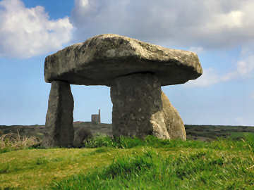
Lanyon Quoit
Located just off the road from Penzance and Madron to Morvah, Lanyon Quoit, along with Trethevy Quoit, is just about Cornwall's most accessible quoit. A late neolithic portal dolmen or chambered tomb, it was brought down in a great storm in 1815. When re-erected in 1824 one upright was broken so now it is like a tripod stool. Before the storm it was apparently possible for a horse rider to pass beneath the 13 ton capstone; now perhaps only a small child on a miniature pony could manage to pass beneath it. Lanyon Quoit, in the care of the National Trust, is only a few yards from the road and is approached by a stile. Park in the small lay-by just round the corner, north of the stile. The area just north of Lanyon Quoit is rich in fascinating antiquities. If you park at Bosullow Common, two loops could take in, to the west, Ch�n Castle and Quoit and Bosullow Trehyllys iron age settlement (on private land) and, to the east, Men-an-Tol, Men Scryfa, the Four Parish Stone, the Nine Maidens stone circle and Ding Dong mine. And a litle way down the road to Penzance you will find Madron Holy Well and Chapel, tucked away in light woodland a little way from the road. Altogether, an area well worth exploring by those interested in Cornwall's amazing antiquities.
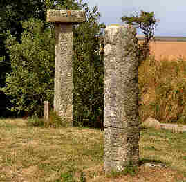
Long Cross Inscribed Stone
I encountered Long Cross inscribed stone - presumably an early Christian period memorial stone - on a round walk from Chapel Amble that took in St. Endellion church and the old manor of Roscarrock. At present I have been able to find out nothing about the stone but was entertained by its proximity to two later direction signs, one of the twentieth century, the other much older. The older has an upright with a flat square stone on top, each side naming a different destination; it is pictured here behind the inscribed stone.
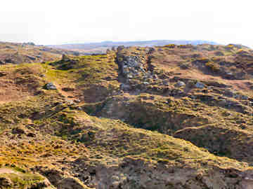
Maen Castle - Cliff Castle near Land's End
When I was last here - in September 2005 - I could never have guessed that Maen Castle was perhaps the most impressive cliff castle in Cornwall, Treryn Dinas notwithstanding. Then the whole site, except the entrance, was covered in bracken and furze and, had I not been looking for the wreck of the RMS Mulheim in Castle Zawn, I would never even have spotted the tiny National Trust sign. On this occasion, in April 2008, I was pleased to discover that the National Trust had cleared the site, exposing what seems to be four concentric rings of wall. The main stone-built wall, through which you enter, must have been absolutely massive; its six to eight foot width suggests a considerable height. Clearly there has been a great deal of cliff erosion - this is probably the most storm-swept part of the Cornish coast - and I guess this must have been a gigantic fort in its day. It is generally believed that it was constructed in around 500 BC and remained in occupation for almost 1000 years. Access along the coast path is fairly easy. It is about halfway between Sennen Cove and Land's End. There is an easy 200 foot climb from Sennen Cove; from Land's End it is more or less level walking. The best place to eat nearby is Sennen Cove where, at one end of the front is the relatively expensive The Beach caf�, at the other end is a caf� with good value breakfast type food.