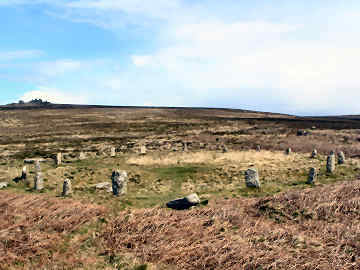
Tregeseal Circle on Carnyorth Common, south of Trewallard
In early July 2006 I headed for West Penwith in search of more antiquities. After spending some time at Sancreed, I parked at Geevor Mine in Trewellard - not far from St. Just and Cape Cornwall - where I returned later to make a report on the museum, and enjoyed a pleasant and an easy four or five mile walk. I found more than I bargained for - at Sancreed Cornish crosses, a holy well and a bronze age barrow; on and around Carnyorth Common, boundary stones, a line of holed stones, a stone circle, an abandoned farmstead and a relatively contemporary farm with ancient field walls. I have to confess that I failed to find the stone circle first time and had to drive up rutted tracks later to find it from a different direction! I was back later on foot, walking the Penwith Round. On the way I drove through Tregeseal village which itself was quite a delight, its colourful cottages and gardens nicely tucked away from the St. Ives - St. Just road. Sadly this circle of around twenty stones, having been restored, was rapidly being engulfed again in bracken. It had turned quite dark and drizzly when I got here, so I got no worthwhile photo then. However, I have been back many times since and discovered that the site is being maintained again, by Cornish Heritage Trust, and is in much better shape.
Tregeseal Stone Circle, Carn Kenidjack on hill above
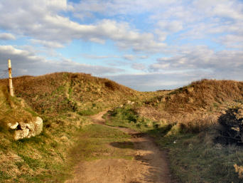
The Land's End Trail passes through here
More in Antiquities
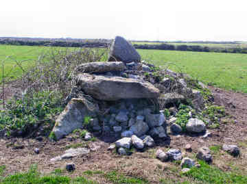
Tregiffian Vean Chambered Cairn near Land's End
The fact that there is a better known Tregiffian neolithic long barrow close to the Merry Maidens in the Lamorna area confused me for a long while. So in April 2008, when doing a walk from Land's End, I looked at the OS map, saw that 'chambered cairn' was shown between Higher Tregiffian and Tregiffian farms, and decided to include it in my walk. It was easy to find, in a long field through which a path runs between the farms and, despite its small size, visible from quite a distance. When I got to it, my first thought was that this was no chambered cairn at all but just a heap of stones that a farmer had piled in a field. However, when I got home and looked it up on the web I found a posting by Pure Joy on The Modern Antiquarian , quoting Craig Weatherhill's book Belerion, Ancient Sites of Land's End as follows: "This barrow has suffered dreadfully and it is only a shadow of the fine and unusual monument excavated by W.C.Borlase in 1878. It was then a kerbed mound 6.4m in diameter, containing a rather odd-shaped chamber. This was 2.4m long, 0.9m wide and just 0.5m high, but its inner end opened out to a width of 1.2m and a height of 1.0m. Like the tomb at Tregeseal the entrance was blocked by a single slab. The roof of the chamber consisted of three slabs and the tomb contained ashes and an urn". Sad that an important ancient monument - it is of the Scillonian type - should have been allowed to be so badly damaged.
Treryn Dinas Cliff Castle
This must be the largest of Cornwall's cliff castles. Depending on who you believe, there are either three or four lines of ramparts. I make it three. A massive landward rampart (right on the coast path) as much as twenty feet high, an inner double bank and ditch, and a small seaward rampart, which is approached by a 'bridge', just before the incredibly rocky headland. There are said to be remains of two hut circles beyond this seaward defence. I find this a puzzling place. Why should anyone who could build the vast outer defences risk being trapped between their tiny final rampart and this rocky headland, with no way to escape. Is it possible that 2000 years have seen massive erosion here, changing the headland beyond recognition. Whatever the reason, it is a most impressive place. It is worth climbing the rocky headland to find the famous Logan Rock - I couldn't make it in the high winds of late March 2008. The National Trust has made a fair job of clearing the site and there is an easy level path from Treen village. For once I disagree with Craig Weatherhill's thoughts on place names. Treen may not mean 'the farm by the fort', it more likely means 'the farm by the (bank and) ditch'. But I do agree that the cliff castle's name is now derived from the village name - 'the fort by Treen'.
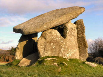
Trethevy Quoit Portal Dolmen
Trevethy Quoit is the best example in Cornwall - and one of the best that you will find anywhere - of what the archaeologists describe as a neolithic portal dolmen, a massive 4000 year old burial chamber of stone construction that would once have been covered in earth. Quoit is the Cornish word for this kind of monument. Seven vast slabs of Trethevy Quoit survive of which one has fallen into the tomb, causing the great capstone (it weighs around ten tons) to slope at an angle that adds character, as does the neat hole drilled through one corner - one suspects that this may have been done in Victorian times in order to put the slab back on top after it had fallen. Another oddity is that the upright 'closure' stone has a bottom corner cut away, apparently in order to allow the chamber to be entered. When looking for Trethevy Quoit, you will find it poorly signed. When you make the designated turn in Darite village, you will then need to make an immediate unsigned right to find it.