Trethevy Quoit Portal Dolmen
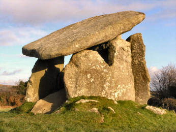
Trevethy Quoit is the best example in Cornwall - and one of the best that you will find anywhere - of what the archaeologists describe as a neolithic portal dolmen, a massive 4000 year old burial chamber of stone construction that would once have been covered in earth. Quoit is the Cornish word for this kind of monument. Seven vast slabs of Trethevy Quoit survive of which one has fallen into the tomb, causing the great capstone (it weighs around ten tons) to slope at an angle that adds character, as does the neat hole drilled through one corner - one suspects that this may have been done in Victorian times in order to put the slab back on top after it had fallen. Another oddity is that the upright 'closure' stone has a bottom corner cut away, apparently in order to allow the chamber to be entered. When looking for Trethevy Quoit, you will find it poorly signed. When you make the designated turn in Darite village, you will then need to make an immediate unsigned right to find it.
There are several other ancient sites nearby worth visiting: the Hurlers stone circles and Pipers standing stones just north of Minions and King Doniert's Stones two miles south-west of the same village. Nor should you miss the wooded River Fowey at Golitha Falls about four miles south-west of Minions, a delightful spot with beech woods and impressive waterfalls.
Trethevy Quoit Grid ref: 25967/68824
Small amount of parking by the triangular green nearby
Detailed directions for a round walk from Minions, taking in Trethevy Quoit, St. Cleer Holy Well and King Doniert's Stones, can be found on my Bodmin Moor Walks page. The walk is an easy one of about 6� miles.
***********************************************************************************
More in Antiquities
Trevelgue Head Iron Age Promontory Fort
If you look at the Modern Antiquarian you will find some confusion about Trevelgue Head Promontory Fort at St. Columb Porth. Phil's fieldnotes are immaculate but a number of photographs have been posted of quite a different site, the pair of bronze age barrows on the cliff top above Fruitful Cove, more than half a mile to the north. Trevelgue headland is now split in two, its parts now joined by a small wooden footbridge. One wonders whether the gap had to be bridged when the fort was in use for around 800 years from the 3rd century BC. Consensus seems to be that sea erosion created the gap more recently. Fortifications - still impressive banks and ditches - date from iron age occupation and are on both the mainland and the island. But the site must have been occupied from long before the iron age; archaeologists have found some evidence of metal working from the bronze age and the discovery of flint chips may suggest neolithic occupation. Indeed, there is still a fairly impressive bronze age barrow, though others have been robbed out, probably by modern day farmers in search of building stone, as they did on Barrowfields not far away in Newquay. Trevelgue Head can be seen from the barrows above Fruitful Cove and from those at Barrowfields so there is more than likely a bronze age tribal connection. I sought out all three sites during a walk on the Coast Path between Watergate Bay and Newquay.
Warbstowbury Hill Fort
The name may look very un-Cornish but then you are are in north-east Cornwall where the people, and therefore the place names, are mainly Anglo-Saxon. The village of Warbstow probably takes its name from Werburg's church and the bury suffix means, in this case, fort. I made a visit in May 2007, after a walk from nearby St. Clether. I found that the site is in the care of North Cornwall District Council, is in quite good order, probably thanks to the sheep that graze the site, and that there is a small car park on the road from Hallworthy to Warbstow. I would hazard a guess that it is mainly a haunt of dog-walkers.
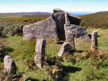
Zennor and Mulfra Quoits
Quoits