Looe - a change of heart on a south coast resort town
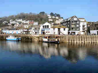
When I originally reported on Looe a few years ago, I was very harsh about it, really seeing only the tourist tat. In March 2009 I was in Looe when walking the Smugglers Way. I spent some time walking around the more interesting bits and taking a number of photos. Chris Halls, who runs the 'I Love Looe' website, had taken me to task about my scathing judgment on his town. Having been back in Looe and looked at it through different eyes, I am now happy to revise my original view - though not entirely. Looe comes in three parts. Divided by the River Looe are East Looe, the town's main resort and shopping area, and West Looe, residential and poor shops. The two are joined by a handsome many-arched bridge. Beyond West Looe is smart residential Hannafore with a beach. East Looe has an attractive waterfront with a major fish market, serving Cornwall's second largest fleet (the fish is said to be the best), handsome converted warehouses and the new lifeboat station. Behind these are the charming guildhall and old lifeboat station. Shops and restaurants look better than I remember (but many seem to close in winter) and I have had good fish and chips in Looe. There are lovely walks through Kilminorth Woods along the West Looe River. But, I'm sorry, I still don't like Looe's tatty touristy shops.
More on Looe Another view of Looe Chris Halls' I Love Looe
Banjo Pier is southern terminus of the Smugglers Way
Fishing boats tied up near Looe's Fish Market
PARKING IN LOOE: Perhaps this is really why I don't really like the town. There is a vast car park at Mill Pool on the western approach. It is expensive and only as you walk into town do you discover that you could have parked much more cheaply in Pearns boatyard. There is parking by the quayside in East Looe but it is even more expensive and usually full of shoppers taking advantage of the cheap short-stay rate. We prefer to park free in Hannafore and walk.
More in Towns & Villages
Lostwithiel
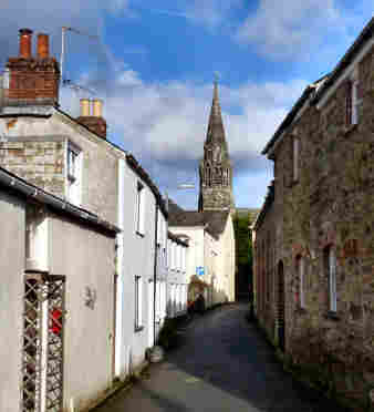
This small Cornish town has a lot to offer – history, charming unspoiled streets and the county’s best concentration of antique shops, varying from quality to bric-a-brac. Once Lostwithiel was a place of considerable importance. At the end of the 13th century Edmund Earl of Cornwall rebuilt the castle in stone and Lostwithiel then became the administrative centre for the county. It had a port on the River Fowey, exporting tin, the trade in which was managed from the Stannary Court in the Shire Hall, which also operated as the County Treasury. When the Earl of Cornwall was made Duke, the Shire Hall grew into the Duchy Palace. When the river silted up in the 15th century, Lostwithiel lost its tin trade but developed others, pottery, weaving, tanning and pewter-making. St. Bartholemew’s church has an unexpected spire of elaborately carved granite. Unusually, the streets form a grid pattern, originating in medieval times. Fore Street has the shops and tea rooms. Quay Street, by the River Fowey, has former lime kilns at one end, at the other the remains of the old Duchy Palace, behind the heavily buttressed former ‘Coinage Hall’. Across the river, a new apartment development utilises Victorian railroad buildings.
Luxulyan
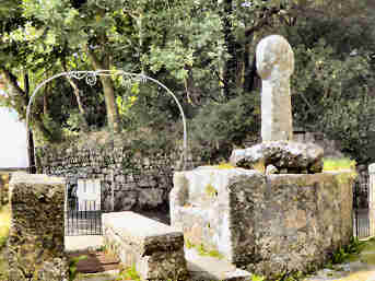
I have long been familiar with the Luxulyan Valley and Jane and I have enjoyed many walks from Ponts Mill to the Treffry Viaduct, heading up along the river past J. T. Treffry's China Clay Works and returning on the other side of the valley past the impressive Carmears Wheelpit. It is a delightful walk through lovely beech woodland. I had been in Luxulyan village on only a couple of occasions, both when walking the Saints Way. On this occasion in mid-August 2016, Luxulyan was one of group of visits; first I visited Lanivet for the church then I stopped in Lockengate to photograph a roadside Cornish Cross. Then, still heading for Luxulyan, I continued by way of Bodwen and Lanlivery. The first attraction of Luxulyan is its churchyard, for the lych gate with its Cornish Cross and its lantern cross. The second attraction is the Holy Well below the church, restored but sadly not in water. The church itself is almost certainly on an ancient site, a small promontory at the top of a steep hill overlooking the valley. It has nave, two aisles and a three stage battlemented tower, typically Cornish. There is nothing special about its interior, except for the attractive font and the colourful altar. One more thing about Luxulyan - it is pronounced Luxillian.
Madron
Madron lies a little to the north of Penzance, just off the road to Bosullow Common, Lanyon Quoit, Men-an-Tol and Nine Maidens Common. As you drive through you are hard put to decide where to park but, if you head for the church and school, there is ample parking. There is more here than just an impressive church: within the churchyard are two impressive memorials - a great mausoleum to Rose Price and a globe-bestriding statue with an unreadable dedication - and two Cornish Crosses (there are two others nearby). Inside, the roofs have carved wooden bosses, there are two attractive screens and the south chapel has an alabaster plaque of saints, some ancient bench ends topped by beasts. High on a wall is the "Nelson Banner", carried in the procession that celebrated Nelson's victory at Trafalgar. In addition to the two Cornish crosses in the churchyard, there are two others nearby, one in a field to the south of the church at 45436/31503, the other on a lane near Madron Well and Chapel, at about 44512/32541. Well and Chapel are worth visiting, the former a spring identified by trees adorned with strips of cloth, interceding for family or friends, the the latter substantial but roofless. Both sites are cared for by the admirable Cornwall Heritage Trust. Nearby is the National Trusts' lovely Trengwainton Garden.