Portreath
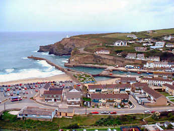
Jane remembers Portreath from wartime when her father used to explain why the village was closed. When we visited in 2003, I was taken by the long narrow harbour, almost unused, and by postwar housing occupying a level V-shaped section between harbour and cliffs. Portreath is now a very ordinary down-market little resort, blessed by a safe sandy family beach but I wanted to find out something of its history. It turns out that it was an 18th and 19th century port, a major player in the tin and copper trade, serving mines around Redruth and Camborne. An important tramway ran from Redruth and is now part of the Coast-to-Coast Mining Trail. A steep inclined plane also ran down from the western side. The port declined in the 20th century and the harbour is now used by a small fishing fleet and by pleasure boats. In World War II Portreath changed beyond recognition. The military took over, clearing away warehouses, and the port served a top secret airfield and weapons storage facility high on the east side at Nancekuke. The warehousing area now has late 20th century housing on it, most of it frankly quite unattractive, while chalets line the cliffs. The airfield remains closed and teams still search for unspecified but apparently deadly hidden weaponry. Below, Portreath's Industrial History
A round walk from Portreath includes Tehidy Park and coast.
Portreath from above; harbour in middle ground
Portreath's Industrial History
More in Towns & Villages
Portreath's Industrial History
At a glance you would be hard put to guess at Portreath's great industrial history. Nowadays it is a combination of dormitory town for industrial Redruth and Camborne and a scruffy looking small beach and surf resort. Yet in the past it has been one of Cornwal's most important ports. The clues are there: a long well constructed double harbour, a mineral tramway trail that runs to the mine sites and on to Devoran, and the remains of an inclined plane heading steeply south from near the harbour. Construction of the harbour began in 1760 and by 1800 it was bustling with copper ore heading for South Wales and coal returning. By 1819 a tramway had been built to bring copper ore from the mines around Poldice and St. Day. In 1836 the Portreath Branchline was built, linking to the important Hayle Railway. By now ships were being built here, too, and fishing was also important. The 20th century saw gradual decline. Tin streaming ceased when the Red River was diverted in 1933. After WWII the harbour lost its industrial trade and the railway closed. The harbour became home to just a small fleet of crabbers and to pleasure boats. The busy industrial area by the harbour was developed for housing. Few clear signs remain of Portreath's former importance except on the north side of the harbour and in the remains of the Branchline's inclined plane.
Portscatho and Gerrans
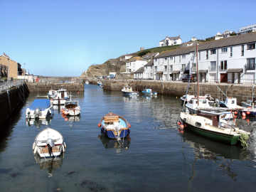
I have a special affection for Portscatho because that's where Jane lived for many years. She still has good friends there are likes to visit from time to time, often for charity coffee mornings. When she went in late July 2007 I went with her and wandered around taking photographs - what else? I was particularly pleased with the somewhat atmospheric one on the left, of the harbour with a distant view of Nare Head and the Dodman. Portscatho is really two villages that have become joined as thay have expanded. Down by the water and along the cliff is Portscatho. Above, originally straggling along the road to St. Anthony Head, is Gerrans, where the church and the Victory pub are. There is still a garage there but the shop and tearooms are gone. Activity has largely migrated down the hill to Portscatho where, partly supported by second and holiday homes, are the Plume pub, a general stores, a couple of art galleries (representing the small colony) and a tea shop. Portscatho harbour remains intact but I doubt if there is any commercial fishing; instead small leisure boats fill the little harbour. Despite visitors there is a strong sense of community and gardens are opened for charity on a day in summer. There is some good walking. A path leads down to Polingey creek and the Percuil river. The coast path to Portloe is of moderate grade; to St. Anthony Head is easy.
Poughill
Poughill -pronounced Puffle, is tucked away on a quite lane, leading to Northcott Mouth, on the north side of Bude. It is a steep village and the lane is narrow but, fortunately, there is a good sized car park below the church. There are some attractive cottages, particularly Church Cottage and St. Olaf's Cottage. St. Olaf's Church, dedicated to the Nowwegian King and Martyr, stands on a knoll, perhaps suggestive of an ancient site. The (unused) oak tower door has an impressive surround. The porch, in it a slate memorial in Latin, has an ancient studded oak door. Inside, wagon roofs have carved bosses. The frescoes of St. Christopher are a remarkable survival; whitewahed at the Reformation, they were rediscovered in 1894. The elaborately carved pulpit is unusual for its open fretwork. A wall plaque commemorates Sir Goldsworthy Gurney, Wadebridge doctor, builder of Bude Castle, inventor of a fast steam road carriage, whose limelight lighted the houses of Parliament for 60 years. As at Kilkhampton, there is a fine collection of early bench ends. The attractive looking Preston Gate Inn, which also calls itself a caf�, is open 11 to 11 every day and does interesting sounding food lunchtime and evening. Produce is mostly local and there are fish and chips on Friday, roasts on Sunday and the occasional curry evening.