
Saltash
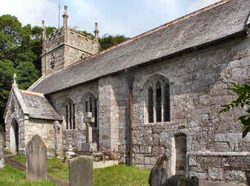
Saltash stands across the broad River Tamar from Plymouth. Two great bridges cross the river: Isambard Kingdom Brunel's great rail bridge of 1859, a remarkable feat of engineering, and the impressive road bridge of 1962. A foot and cycle path runs alongside the main carriageway, so you can walk or ride across to the Plymouth side. Saltash itself is one of Cornwall's larger towns with a population of around 16,000 at the last census in 2011. It has a long history, being recognised as a borough by 1201, but has suffered in the 20th and 21st centuries. Still a thriving town and fishing port well into the 20th century, it was badly hit by bombing in the 2nd World War and has been in some degree of decline ever since. Thanks in part to the construction of the road bridge, and a tunnel leading to it, much old housing had to be demolished. What was picturesque housing along the waterfront is long gone, as is the former fishing fleet. The only touch of interest on the waterfront is the Union Inn, its colourful murals by local photographer and artist Mick Lobb, and statues of Brunel and Ann Glanville. Now that the waterfront has lost its former significance it is up the hill in the main part of the town that the worthwhile buildings are to be found. I parked in a reasonably priced car park off Albert Road and found that I had picked the ideal spot. Just to my left was a small memorial 'Peace Park' with interesting memorial seats (and even a memorial WWI litter bin) by David Ogilvie, whose work can be found all over the country. I sat there for a while and realised I had really picked the ideal spot. Directly ahead of me was a war memorial with elaborate gates with two illustrative plaques, to its left the Church of St. Nicholas and St. Faith, to the left again the attractive Guildhall. The Guildhall stands on the corner of Fore Street which leads to pedestrian access to the Tamar Road Bridge and on down to the waterfront. Disappointingly I had managed to pick the wrong day - Saturday- and not only was the church closed but so was the Guildhall. i was later able to visit both; the Guildhall is open on weekdays, the church occasionally. I walked a little way down Fore Street and found the entrance to the pedestrian walkway along the road bridge. At its entrance I was looking across to the lovely "Cornish Cross" that Jane and I had made an expedition to see when it was first erected in 2013. This time, it glinted colourfully in the strong sun. Below the bridge, in a grassy area, there is a plaque by Thrussell and Thrussell. As for the church, its late Victorian period may well reduce its interest to visitors; if so, you should definitely visit Saltash's mother church, St. Stephens, about a mile from the centre on St. Stephens Road, which leaves Callington Road where it becomes Fore Street at Victoria Gardens.
Saltash Waterfront
Saltash's Attractive Guildhall
Tamar Cross
David Ogilvie Saltash Peace Garden Seat
Photographs
More in Towns & Villages

Saltash Waterfront
At the very end October 2018 I revisited Saltash, partly in the hope of seeing inside St. Nicholas and St. Faith (I was successful) and partly to visit the waterfront on the broad River Tamar. As Pevsner points out the waterfront is not what it was; now there is no fishing fleet, no commercial activity except a couple of pubs and a cafe. One of the pubs, the Union Inn, is colourfully decorated with a Union Flag on its front and a mural on one side. Head a little upstream and you get a fine view of the undersides of the two great bridges. Back a little downstream and you find a statue of Isambard Kingdom Brunel, admiring his great rail bridge of 1859. Nearby the figure of Ann Glanville sits on a bench: she lived from 1796 to 1880 and became a celebrity for her achievements as a gig rower. Quite unexpected here is a reproduction of a Turner painting of old Saltash waterfront, but why on earth is the artist not credited? Also unexpected is a pub, the Ashtorre Rock Inn, almost directly beneath Brunel's rail bridge. Nearby, in front of the Just Be Cafe and wine bar, is a large impressionistic sculpture of a boat and oars.
Sancreed
I have been in Sancreed, way down west in West Penwith, almost to Land's End, on three occasions. The first was in July 2006, the second in March 2008 then, after a gap of more than nine years, I was back there in October 2017. In 2006, in search only of antiquities, I had ignored the village and had been to Sancreed Beacon and Caer Bran. In 2008 I had concentrated on the church itself and he nearby Holy Well and Baptistry Chapel. This time, in October 2017, the church was closed for renovation so I again concentrated on the Cornish Crosses, one of the finest church collections in Cornwall: I counted five in all, including one on the graveyard hedge to the road and one on the wall by the main steps. I hope to revisit when the church restoration is complete in, probably early in 2018. In the meantime, some information gleaned from Pevsner. Saint Sancredus church is largely of the 15th century and consists of nave, north transept and short pinnacled tower. The porch has an original wagon roof. Inside are remains of a rood screen with amusing carvings and a 15th century font. Some notable artists are buried in the churchyard, including Stanhope Alexander Forbes, Elizabeth Adela Forbes and Thomas Cooper Gotch. Nearby, a holy well and baptistry are marked by a modern Cornish Cross. 2019 - restoration complete, see item on my holy sites page.
Seaton
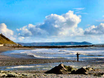
Previously, I had only been in Seaton when passing through walking the Cornish Coast Path and had paid it little attention except to be surprised by the greyness of the beach. This time I made a proper visit in February 2016 in order to see what it really looked like and to find out what I thought of it. Seaton is a strange place, unlike anywhere else I know on the Cornish coast. You automatically think of Cornwall's beaches as being sandy and golden; not Seaton's which is of rounded slate stones, blue-grey in colour. The little River Seaton, which rises only 10 miles or so away, on the fringes of Bodmin Moor, not far from Minions, bisects the beach. Not surprisingly, rising in mining territory, the little river has suffered from bad copper and arsenic pollution. Presumably it is this mineral pollution that has led to to blue-grey colour of the beach and its shingle. The last two miles of the river's course is through Seaton Country Park; you can walk through it for 2 miles to Hessenford. Views from the beach are to Looe to the east, Rame Head to the west. Surprisingly, there are three places for refreshment in the little village: a good beach caf� with an extended outside undercover seating area and the excellent value Smugglers Inn (note pensioners and fish and chips prices). Waves, a fairly new glass fronted caf�-bar, overlooks the beach.