Warbstow
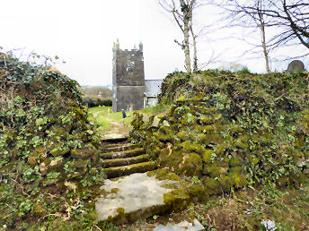
This expedition, in late February 2016, started as a revisit to Warbstowbury, a vast iron-age hill-fort not far from Camelford in North Cornwall, and Cornwall's second largest after Castle-an-Dinas near St. Columb. I enjoyed walking the circuit of the banks and ditches of the hill-fort and got some good photos of the views from there, taking advantage of the 800 foot height of the location to include such landmarks as the dishes and radomes of GCHQ Steeple Point north of Bude. I then moved on to Warbstow, passing through Warbstow Cross, a village of no interest. Warbstow itself is tiny, consisting just of farmhouse, ancillary buildings, church and a formerly occupied house, for sale when I was there in 2016. The farm's old barns, mostly no longer in use, are attractively ramshackle. One low building, which might have been a small piggery, has a small double-headed round window opening. The farmer describes it as Norman but it looks Saxon to me. Oddly, the village's name means "the holy place of St. Werburg", a saint normally associated with Chester. I was unable to gain access to the church but underatand it originally to have been 12th century cruciform, an aisle and tower added in the 15th Century and the south transept removed in 1861. Note the coffen stile through the hedge to the churchyard from a lane on the south side.
From A39 N of Camelford, go R on A395 and L at Hallworthy
Coffen stile leading to Warbstow church
More in Towns & Villages
Warleggan
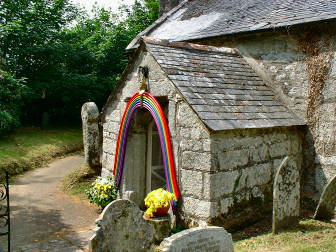
I first encountered the moorland village of Warleggan in June 2006 when Jane and I attended a flower festival there. It was a warm, sunny day and gardens were looking lovely and lush. I was next there in August 2011 in the course of a challenging 6� walk from a car park at the southern end of Colliford Lake, a walk that took me over Penkestle and Letter Moors, and by way of Lantewey, Warleggan and Carburrow Tor. Challenging for the stream crossing below Lantewey - the clapper bridge had collapsed in a flood - and the very steep, massively rocky track up between Lantewey and Warleggan. On this occasion, in late November 2016, I approached the village from the A38 at the Halfway House Inn and, on the way, discovered disused Tredinnick Chapel and an adjacent Cornish Cross. Warleggan is a fairly steep, one street village. There are some inaccessible big houses, accessible small cottages, the former village pump in front of Pixie Nook (ugh!) and the tiny church up a track off the lane. There is little to commend the church, which was (as so often) ruined by Victorian "restoration". The 15th century font of elvan stone bears no decoration. The poor box is old but stands on a modern column. There are no carved bench ends, done away with by the Victorians. To my mind about the only redeeming features are the Cornish Cross, once used as a gatepost, by the porch and the fact that you can park a car by the church.
Week St. Mary
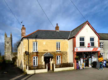
I visited Week St. Mary (originally Wyke St. Mary, the Old English Wyke meaning a dairy farm, St. Mary added for the dedication of the church) in late January 2016. My purpose was essentially to seek out the bare remains of what is claimed to be a Noman castle ringwork just to the west of the church. Certainly you can see some kind of earthwork in the field adjacent to the church but just what it was is unclear from visual evidence, whether castle or perhaps manor house. The village will have been in existence since before the Norman Conquest, after which the land belonged to William the Conqueror's half brother, Robert of Mortain. The market square is attractive with a couple of thatched cottages, a colourful cottage next to the village shop, and a view of the church tower. St. Mary's church, largely of the 14th and 15th centuries, is typically Cornish in that it has nave and north and south aisles, the aisles with wagon roofs. In the porch the floor is of vertically set slate tiles, reminiscent of a Lutyens garden path; underneath a bench is the original village stocks. Inside, the Three Martyrs window is by Kempe; the octagonal font has unusual crude carving; the pulpit has linenfold panelling and a nearby stall looks as if it was made from the former rood screen. The 1814 memorial plaque to Joseph Burnett records the death of the the oldest known official peace officer killed on duty. Note how the word duty has been at first omitted but later added.
Zennor
Just off the scenic north coast road from St. Ives to St. Just-in-Penwith is a tiny charming village, too easily passed by on your way west. Zennor consists of just an essentially Norman church, a cattle farm, the excellent Tinners Arms Pub, a backpackers hostel with tea rooms, a group of holiday cottages known as Post Office Row, and the excellent and surprisingly comprehensive Wayside Folk Museum. Legends attach to the church. One concerns its founder St. Senara, cast afloat in Brittany in a barrel and washed ashore in Ireland, returning with her son, Budoc, who was born at sea, via Cornwall where she founded the church. The short walk to the towering cliffs is rewarding, with views over Pendour and Porthzennor coves. By the coast path, it's a tough 6 miles to St. Ives and 11 to Cape Cornwall. However, you may like to consider the Zennor Churchway, an inland route between the two, with its return over the hills on the Tinners Way.