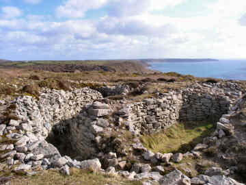
Bollowal Bronze Age Barrow
No one even knew this was there until 1878 when Cornish antiquarian W C Borlase discovered it under mining spoil. There are probably several similar barrows still hidden under the rubble elsewhere along here. The barrow was in use during both neolithic and bronze ages and includes an entrance grave, a cairn, several individual burial cists and a number of ritual pits. What you see is very striking: a central oval structure, 35 feet across with walls up to 10 feet high; all around this is a passage six feet wide with outside walls forming a 'collar' of the same height.
The location of Bollowal Barrow is superb, just back from a 300 foot cliff with views north to Cape Cornwall and the Brisons rocks, south to Land's End and the Longships Lighthouse. On a clear day you can see the Isles of Scilly more than 30 miles away. You can drive to the site by taking the road from St. Just signed to Cape Cornwall for half-a-mile and then turning left on Carn Gluze Road for three-quarters of a mile. If you are fit, however, it is far more enjoyable to climb the steep coast path from the National Trust car park at Cape Cornwall. For refreshments close by you can't beat the egg and bacon baps at Cape Cornwall Golf Club, England's most westerly and most wind blown course.
Bollowal Barrow and the view to Land's End
Barrow seen on a Cape Cornwall to Sennen walk
More in Antiquities
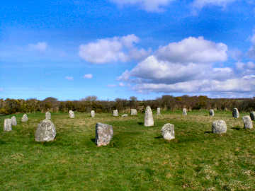
Boscawen-un Stone Circle and Trelew Longstone
In July 2006 I did a figure-of-eight walk from St. Buryan in West Penwith, mostly to find several new antiquities. On the first, southern, loop to the coast I found Cornish crosses near Boskenna, one built into a hedge by a stile. On the second, northern, loop I sought out Boscawen-�n Stone Circle and nearby Trelew Longstone. Boscawen-�n is a circle of 19 stones, a leaning 20th at its centre, a little to the west of Boscawenoon Farm. I understand the nineteen stone circle is the standard Cornish formation, though few remain thus. If you want to arrive by car, there is room for about 6 cars to park on the A30, about 2 miles west of the St. Buryan turn; a small wooden sign points towards the circle. I was back again in March 2008 while walking the Penwith Round. This time I also sought out the Trelew Longstone, eight feet high, standing near the edge of a field of maize and visible from a lane leading to Trelew Farm from the south-east. If not walking, I imagine you can probably ask at Trelew Farm for permission to park and to visit the longstone. On both walks I enjoyed coffee and a snack in the pub in St. Buryan and admired the handsome church there, itself the possessor of two Cornish crosses.
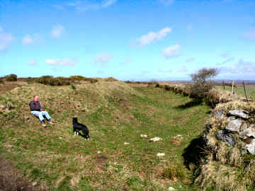
Caer Bran Hill Fort
Bran Hill Fort
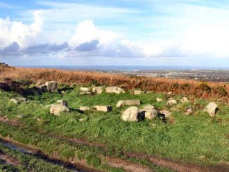
Carn Brea - the hill overlooking Camborne and Redruth
This impressive hill, a ridge a mile long, towers over Camborne and Redruth. Views are superb but mostly to the north. The visible archaeoloogy is something of a disappointment. An important neolithic settlement of the early 4th millennium BC had an 8 acre enclosure surrounded by an 11 acre enclosure, occupied by a hundred or so people. Later, iron age occupants streamed for minerals and traded as far as Kent. In medieval times stone was quarried and the Bassetts hunted from their 'castle' hunting lodge, Carn Brea Castle. Most prominent feature of the hill is the great monument commemorating Francis Bassett, Lord de Dunstanville, a major mine owner. The hill is much overgrown with furze, brambles and bracken and all I have been able to find are a couple of standing stones, some boundary stones and two hut circles. Perhaps a serious heath fire might expose what the experts found in the 1970s. Although, when visiting Carn Brea, which I have done many times, I prefer to walk, making a variation to the Great Flat Lode Trail, you can drive to the top of the hill. A track leads up from Carnkie village and you can park not far from Carn Brea Castle. Carn Brea should not be confused with Chapel Carn Brea, with its vast cairn, which is not far from St. Just-in-Penwith.