Caer Bran Hill Fort
Bran Hill Fort
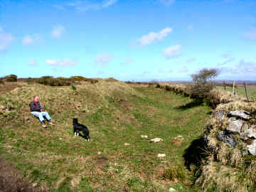
I encountered Caer Bran for the first time in March 2008 when walking the Penwith Round. I really should have been there before, located as it is halfway between Sancreed Beacon and Carn Euny. However, the Ordnance Survy map gives the site little significance, and there is little about it on the web, so I hadn't previously given it a thought. I was glad I did so on this occasion. Apparently the site was largely furze covered but PAROW, the Penwith Access and Rights of Way group, has done some clearance recently though much more needs to be done. To my mind, the place is an oddity, an iron age hill fort with - according to a Cornwall Archaeological Unit 1990s survey - several bronze age ring cairns inside its 240 foot diameter outer rampart. What I saw seemed shaped more like longhouses! The name could mean Crow's Castle or it could take its name from nearby Brane (Bos Vran - the House of Bran). Or could it be anything to do with the Rialobran commemorated on Men Scryfa near Men-an-Tol and the Nine Maidens circle? I feel this is a site that might benefit from the attentions of Time Team and perhaps from being put in the care of the Cornwall Heritage Trust, which has done such a good job elsewhere. Anyway, it's a spot well worth visiting if you are in the area. There are long views though less than those from nearby Sancreed Beacon.
Off lane from Grumbla Common, opp. Caer Bran farm
The outer rampart in the south-east sector
Carn
More in Antiquities
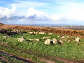
Carn Brea - the hill overlooking Camborne and Redruth
This impressive hill, a ridge a mile long, towers over Camborne and Redruth. Views are superb but mostly to the north. The visible archaeoloogy is something of a disappointment. An important neolithic settlement of the early 4th millennium BC had an 8 acre enclosure surrounded by an 11 acre enclosure, occupied by a hundred or so people. Later, iron age occupants streamed for minerals and traded as far as Kent. In medieval times stone was quarried and the Bassetts hunted from their 'castle' hunting lodge, Carn Brea Castle. Most prominent feature of the hill is the great monument commemorating Francis Bassett, Lord de Dunstanville, a major mine owner. The hill is much overgrown with furze, brambles and bracken and all I have been able to find are a couple of standing stones, some boundary stones and two hut circles. Perhaps a serious heath fire might expose what the experts found in the 1970s. Although, when visiting Carn Brea, which I have done many times, I prefer to walk, making a variation to the Great Flat Lode Trail, you can drive to the top of the hill. A track leads up from Carnkie village and you can park not far from Carn Brea Castle. Carn Brea should not be confused with Chapel Carn Brea, with its vast cairn, which is not far from St. Just-in-Penwith.
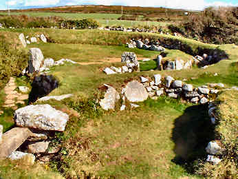
Carn Euny Iron Age Village
Euny Iron Age Village
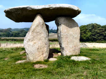
Carwynnen Quoit - or the Giant's Quoit
I first encountered this site when walking the Land's End Trail in an east to west direction in 2007. Carwynnen Quoit, also known as the Giant's Quoit or Devil's Frying Pan, was, when I first saw it, a totally collapsed neolithic burial chamber. To look at it then you might have wondered if it were not just a heap of rocks but there was an image of it still standing in The Modern Antiquarian. Apparently it was re-erected in the mid 20th century, only to collapse again in 1983. Now (2014) it has been re-erected by the Sustainable Trust which acuired the site in 2009. Fund-raising and acquiring the co-operation of official bodies enabled re-erection in 2014. Carwynnen Quoit is not entirely easy to find. You need to get to the tiny settlement of Carwynnen - where you can probably park - take the hill up towards Troon and go through a gate on the left. Just inside the field is an informative storyboard. When I re-visited in September 2014 I chose an alternative route. I parked in fascinating Treslothan villlage - well worth a visit in its own right - and walked through fields and woods to the road from Troon to Carwynnen, turning right to find the site. The Sustainable Trust has made a great job of restoration - though it will be some time before the now clean stones settle back into the landscape.