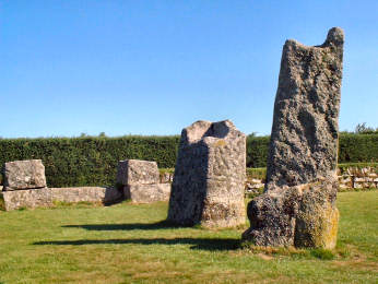
King Doniert's Stones
In a nicely maintained granite-walled enclosure, on the minor road between Doublebois and Minions, are a couple of granite standing stones, with handy car parking by the site. It is unclear whether they were always two or whether they are one broken in two. You will find it impossible to read the inscription carved in the granite but a plaque nearby carries the information: 'King Doniert's Stone. Men Myghtern Doniert. These two granite cross bases (if they are indeed separate) are decorated in the late Ninth Century style and probably date from that time. The shorter stone carries a Latin inscription "Doniert Progant Pro Anima", saying "Doniert ordered [this cross] for [the good of] his soul". Doniert was probably Durngarth, King of Cornwall who was drowned in AD875. The two stones have rectangular sockets on their top and probably carried wooden crosses'. Durngarth apparently drowned in the River Fowey near Draynes Bridge (a mile west), possibly at scenic Golitha Falls, reviewed on my 'Countryside' pages. Other sites to visit around Minions include Trethevy Quoit, the Hurlers and Pipers stones and Stowe's Hill. It is also well worth following a quiet signposted footpath along the old mineral tramway south towards the village of Crow's Nest to find the gaunt ruins of South Caradon Mine and the pleasant Crow's Nest Inn, where we have enjoyed many a hot baguette.
King Doniert's Stones
OS109. Site in the care of Cornwall Heritage Trust
Detailed directions for a round walk from Minions, taking in Trethevy Quoit, St. Cleer Holy Well and King Doniert's Stones, can be found on my Bodmin Moor Walks page. The walk is an easy one of about 6� miles.
The
More in Antiquities
Lamorna - the area to the west of the village
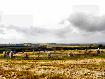
Ever since December 2003, when my sister Mary and I did a round walk from Lamorna that included coast, Boskenna Cross and the Merry Maidens, I had been meaning to return to find the many other antiquities in the area. At last, in July 2007, I did it. After an early lunch at the Lamorna Wink Inn I left my car in their car park (with permission) and set out up the hill opposite to a path that took me west past three farms - Tregurnow, Rosemodress and Tregiffian - then north-west to Boscawen Ros Farm, the original home of the Falmouth's of Tregothnan. There I found my first standing stone in the middle of a field. Continuing north-west I found Boskenna Cross on the main road, then on up a lane to Moorcroft Cross. From there by a path south-west from Choone Farm for massive Goon Rith standing stone. On to the main road for Tregiffian Long Barrow (the cup marked stone is a concrete copy of the original in the Royal Cornwall Museum), then another cross, the Pipers standing stones and Merry Maidens stone circle, one of Cornwall's most complete with 19 regularly placed stones. Oddly, you cannot see one Piper from the other and you can't see the Merry Maidens from either, despite proximity. Yet you can see the Maidens from Goon Rith standing stone. Around 6 miles and very enjoyable.
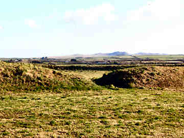
Lanteglos-by-Camelford - Castle Goff and St. Julitta's Well
Having passed close by, on the Camel Ramblers November 2008 AGM Day walk, in dull and wet conditions, I took the opportunity of a fine day soon after to return to Lanteglos to take a look at Castle Goff and also to seek out St. Julitta's holy well. Until 2004 the site would have been inacessible on Castlegoff Farm land but was cleared and is now managed under the Countryside Stewardship scheme. There is easy access on foot from Lanteglos village. Tha name Castle Goff is strange. It is thought to mean (the) smith's castle. Why? Was it a metal working site at one time? It is described as an iron age hill fort but, surely, was no more than a fortified farmstead. In addition to the 80 yard diameter circle of bank and ditch, there are traces of a western extension. Just quarter of a mile to the north-west is another ancient site, shown as 'settlement' on OS109. It's circular and several times the area of Castle Goff. A more recent track cuts across it. St. Julitta's Holy Well is in the grounds of Juliot's Well Holiday Park. Julitta was one of the many saintly offspring of the fecund Welsh King Brychan. To find the well just follow the drive till it becomes a green lane downhill. At the bottom, head left to near the second pond. You will find it there under a tree.
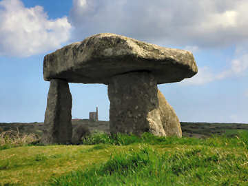
Lanyon Quoit
Located just off the road from Penzance and Madron to Morvah, Lanyon Quoit, along with Trethevy Quoit, is just about Cornwall's most accessible quoit. A late neolithic portal dolmen or chambered tomb, it was brought down in a great storm in 1815. When re-erected in 1824 one upright was broken so now it is like a tripod stool. Before the storm it was apparently possible for a horse rider to pass beneath the 13 ton capstone; now perhaps only a small child on a miniature pony could manage to pass beneath it. Lanyon Quoit, in the care of the National Trust, is only a few yards from the road and is approached by a stile. Park in the small lay-by just round the corner, north of the stile. The area just north of Lanyon Quoit is rich in fascinating antiquities. If you park at Bosullow Common, two loops could take in, to the west, Ch�n Castle and Quoit and Bosullow Trehyllys iron age settlement (on private land) and, to the east, Men-an-Tol, Men Scryfa, the Four Parish Stone, the Nine Maidens stone circle and Ding Dong mine. And a litle way down the road to Penzance you will find Madron Holy Well and Chapel, tucked away in light woodland a little way from the road. Altogether, an area well worth exploring by those interested in Cornwall's amazing antiquities.