St. Keverne and the Surrounding Area
Keverne and the Surrounding Area
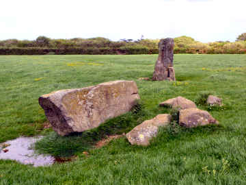
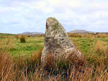
In May 2007 I walked from St. Keverne, one of my favourite villages (and probably my very favourite on the Lizard peninsula), in search of antiquities. Despite some Open Access land, shown on the OS map but fairly inaccessible, it wasn't much of a walk. However, I found most of what I was looking for. Tremenhere Longstone and Trelanvean Cornish Cross are easily found by following a footpath - reasonably well waymarked - that leaves Laddenvean on the north-west fringe of St. Keverne. From the centre of the village, it's about a mile to the longstone, three miles to the cross. For the cross, if there are dogs in the garden of Trelanvean, go through the farmyard. On the way back, I failed to find Three Brothers of Crugith cist which, though on Open Access land, seemed quite inaccessible. (I have since learned that others have found it but with difficulty). However, nearer St. Keverne, I found Crousa Common Standing Stone and Fallen Stone. To get at these, you need to follow a lane heading for Tremenhere Farm to a gate at the far end of the field - or detour from the path to the other sites at Tremenhere Farm. Interesting antiquities - even if I didn't find everything - but a walk with no especial pleasure to it. I would much rather be on the coast or up in the hills on Bodmin Moor or on the moorland of West Penwith.
OS Explorer 103. You can park in the square in St. Keverne.
Crousa Common Standing Stone and Fallen Stone
More in Antiquities
Stannon and Fernacre Stone Circles
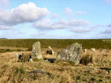
On a cold sunny day in late January 2008 I set off to find three stone circles on Bodmin Moor - Stannon, Fernacre and Louden. Stannon is to the south of the china clay pit and I was able to park within 100 yards. From there I headed south-west for Louden Hill circle. I didn't find it this time but did find it later in the course of my Camelford Walk 01. So I headed for Fernacre circle, clearly visible from almost a mile. On the way I encountered numerous cairns and standing stones and two cists, the Steping Hill one visible from a distance. Then, after climbing Roughtor and exploring the settlement on the hill's south-west side, I headed off to Louden Hill for the logan stone. From Louden Hill, if you look across to the nearest hill westwards, you might think you see quoits and standing stones but the hill is a Stannon Pit spoil heap and they have been placed there for fun. But what I did find, at the western base of Louden Hill, close to the Stannon Pit boundary fence, was an impressive (I assume) hut circle, its walls two or three feet high and grass covered. Finally, I followed the boundary of Stannon Pit to find the impressive Stannon stone circle.
Stowe's Hill near Minions
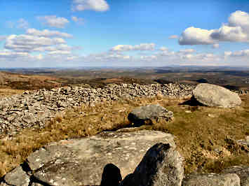
The most concentrated group of interest on Bodmin Moor is on the south-eastern edge of the moor at Minions. A short walk north from the western car park will bring you to The Hurlers and Pipers, ancient standing stones. Legend has it that the three stone circles of the Hurlers are teams of sportsmen, turned to stone for playing hurling on a Sunday; the nearby two Pipers standing stones provided the musical accompaniment. A longer walk to the north leads to a fascinating area at Stowe's Hill. Here, south of the summit, is Daniel Gumb’s Cave where a simple stone-worker, self-taught mathematician, carved a Euclid theorem on a rock. Climb to the top of the hill, around 1300 feet above sea level, one of the moor's highest points, and you will find the quite amazing Cheesewring, a natural granite outcrop, precariously poised above a quarry. Beyond is a massive stone-walled pound, possibly bronze age, and beyond that a larger walled enclosure. Views over the moor are glorious; to the north you are looking to the high tors of Brown Willy and Rough Tor, to the south you can see the sea as far as Dodman Point, to the east you see Dartmoor. South of the hill, beyond a massive deep ditch, is first a degraded cairn and then the famous Rillaton bronze age barrow. The cist, where the gold Rillaton Cup (original in the British Museum, copy in Royal Cornwall Museum) was discovered, is visible on the barrow's east side.
Stripple Stones
I sought out Cornwall's largest - and most unusual - stone circle during a walk in September 2006 that took in King Arthur's Hall, Garrow Tor and Hawk's Tor. The Stripple Stones is a most unusual site because it is Cornwall's only stone circle standing within a henge (circular bank and ditch) - if there were other such henges they have degraded so much as to be unidentifiable these days. The henge is about 225 feet in diameter but now quite shallow and degraded. It seems that no one can agree about how many standing stones there originally were in the circle. Estimates vary from 15 to 28. Only four stand now and the central longstone lies flat. It would be good to see the site cleared and the lost stones re-erected - if they could all be found. Pity is that the location is quite difficult to access so that is unlikely to happen. Location is on the lower southern slopes of Hawk's Tor. It lies on private land but it is to be assumed that the farmer doesn't mind if enthusiasts use his unlocked gates. I was able to approach it from De Lank water works, climbing access land over Carkees Tor and skirting Shallow Water Common before heading south to pass the east side of Hawk's Tor. A fascinating spot and well worth the fairly moderate effort involved in geting to it.