Duloe Stone Circle and St. Cuby's Well
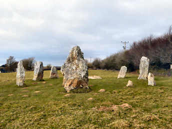
Unusually, this entry appears on three different pages: here under antiquities but also on my towns and villages page and my churches and holy places page. The reason is that, for such a small village, there is so much variety of interest. The form of the church, while not unique to Cornwall, is most unusual. It consists of nave, north aisle, south transept and a strange leaning tower attached to the south transept. The tower was once taller but the top stage was replaced by a pyramidal roof in the 19th century. It leans northwards at a sharper angle than the Leaning Tower of Pisa; fortunately the rest of the church holds it up. Inside, behind an elaborate parclose screen, possibly made from the former rood screen, the chancel aisle was built as the Colshull family chapel and contains Sir John Colshull's tomb, his recumbent effigy on it, and several elaborate slate memorials. The rood loft may be gone but the stair and loft doors remain. About 600 yards south of the church, alongside the road to Looe, is St. Cuby's Holy Well. What is claimed to be his original font was moved from the well site and now stands in the church. A few yards north of the church a sign directs you to Duloe Stone Circle, a small circle of 8 stones, believed by some once to have enclosed a cairn. A storyboard, somewhat weathered, stands by the hedge behind the circle.
Duloe is on B3254, about 4 miles south of A38 at Liskeard
Duloe Stone Circle
More in Antiquities
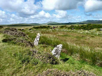
East Moor, Fox Tor and Nine Stones Circle
In early April 2006, having finished walking Mark Camp's Copper Trail, I went back to Five Lanes to investigate an area that I had looked at briefly on the trail and that had attracted me when studying the Ordnance Survey map. This lies just off the Copper Trail, to the south of Five Lanes and the A30 highway. In a fairly complex walk I took a lane through Tregirls and up onto the moor at Eastmoorgate, having checked first that East Moor is an unrestricted Open Access area. Once on the moor I headed up 1100 foot Fox Tor - great views in all directions - where there are traces of a boundary bank and the outlines of former long houses. Then westwards to find what had been a massive boundary bank and on to the south-east up another hill for a stone row and a couple of degraded cairns. South then for the Greymare Rock (not really an antiquity) and hut circles on Carey Tor. Finally northeast to find the Nine Stones circle. My one failure was that I could not find a line of Altarnun parish boundary stones, though I had previously found one near Clitters on a Copper Trail walk. A great walk and fascinating, if mostly rather rudimentary, remains. Afterwards I enjoyed another great, and good value, beef and onion baguette at the King's Head at Five Lanes.

Fox Tor, Nine Stones and Clitters Hill
Clitters Hill
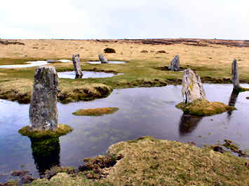
King Arthur's Hall - On OS109 at grid ref: 12963/77623
This is a very puzzling site. There is a rectangular enclosure bank, over six feet high in places and some 160 feet by 65 feet. The inside is lined with apparently random stones, upright, angled or lying flat. Romantics would have us believe that the enclosure was once roofed, hence its name, but its sheer size makes that most unlikely. Its age is a puzzle; its existence was first recorded in 1584 when it was apparently already known as King Arthur’s Hall. According to Craig Weatherhill, in his Cornovia, it could date from the Neolithic period, as do similar enclosures in Ireland and Wales. Some have suggested that it could simply be a cattle enclosure but its interior wetness makes that unlikely. It is noticeable that inside the bank and stones is a well defined rectangle of mares tail grass, inside that a rectangle of cotton grass. This suggests a lining of some sort that holds the moisture. Could it just be that it was a man-made pond or even reservoir to water the cattle on the moor or provide a water source for settlements nearby. Whatever its purpose, the sheer size suggests a place of some importance. It still feels like a special place, perhaps because of its location. Despite nearby farms and villages, you feel total isolation on the high moorland, your views of the higher land of Garrow Tor, Rough Tor and Brown Willy only heightening that feeling.