CORNWALL HERITAGE TRUST
HERITAGE TRUST
Formed in 1985, Cornwall Heritage Trust is surprisingly little known. Its purpose is to protect land of particular beauty or historic, cultural or religious significance; and to preserve and restore buildings, artefacts and other items of similar importance. Its broader aims are to educate the general public and the people of Cornwall; to inspire, not least, Cornwall’s young people about Cornwall’s heritage and to encourage the realisation of its importance to future generations; to promote, with sensitivity, the heritage of Cornwall for the economic well being of the people of Cornwall; and to raise funds and achieve favourable publicity to these ends. Cornwall Heritage Trust also works closely with Cornwall Council's Heritage Environment Service and with CASPN, the Cornish Ancient Sites Protection Network. It also supports local heritage projects and the Historic Churches Trust, sponsors postgraduate students and school education programmes and even sponsors the annual gig races held at Newquay. Cornwall Heritage Trust does a valuable job very well indeed. I have been impressed by the care and maintenance of all the sites they own or manage and hope that all their other aims bear fruit. I wish them well in all their efforts.
Cornwall Heritage Trust Website
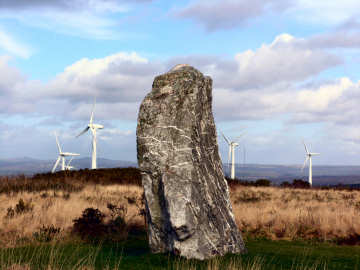
Men Gurta standing stone on St. Breock Downs
Cornwall Heritage Trust owned sites: Trevanion Culverhouse dovecote in Wadebridge, Castle an Dinas iron age hill fort near St. Columb, Sancreed Beacon in West Penwith and the impressive Treffry Viaduct in the Luxulyan Valley.
Sites managed for English Hetitage: Dupath Well near Callington, the Hurlers Stone Circles at Minions, Tregiffian Burial Chamber in West Penwith, St. Breock Downs Monolith (Men Gurta) near Wadebridge, King Doniert’s Stones near Minions, Trethevy Quoit neolithic portal dolmen at Darite and Carn Euny iron age village in West Penwith.
Supported Local Heritage Projects include: St. Piran's Church aand Oratory on Penhale Sands and Perran Round at nearby Rose.
On a personal note, I am at a loss to understand why that particular brand of Cornish Nationalist that defaces English Heritage signs does not instead join Cornwall Heritage Trust and help them to acquire and care for all English Heritage sites in Cornwall - and care for the many other uncared-for sites. Perhaps the Trust's patronage by the Duke of Cornwall (the English Prince of Wales) offends them. Or perhaps their ends are exclusively political. Happily, Cornwall Heritage Trust has been able to persuade English Heritage to remove their branding at the sites the Trust manages. Vandalism has ceased there.
CORNISH
More in Antiquities
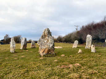
Duloe Stone Circle and St. Cuby's Well
Unusually, this entry appears on three different pages: here under antiquities but also on my towns and villages page and my churches and holy places page. The reason is that, for such a small village, there is so much variety of interest. The form of the church, while not unique to Cornwall, is most unusual. It consists of nave, north aisle, south transept and a strange leaning tower attached to the south transept. The tower was once taller but the top stage was replaced by a pyramidal roof in the 19th century. It leans northwards at a sharper angle than the Leaning Tower of Pisa; fortunately the rest of the church holds it up. Inside, behind an elaborate parclose screen, possibly made from the former rood screen, the chancel aisle was built as the Colshull family chapel and contains Sir John Colshull's tomb, his recumbent effigy on it, and several elaborate slate memorials. The rood loft may be gone but the stair and loft doors remain. About 600 yards south of the church, alongside the road to Looe, is St. Cuby's Holy Well. What is claimed to be his original font was moved from the well site and now stands in the church. A few yards north of the church a sign directs you to Duloe Stone Circle, a small circle of 8 stones, believed by some once to have enclosed a cairn. A storyboard, somewhat weathered, stands by the hedge behind the circle.
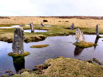
East Moor, Fox Tor and Nine Stones Circle
In early April 2006, having finished walking Mark Camp's Copper Trail, I went back to Five Lanes to investigate an area that I had looked at briefly on the trail and that had attracted me when studying the Ordnance Survey map. This lies just off the Copper Trail, to the south of Five Lanes and the A30 highway. In a fairly complex walk I took a lane through Tregirls and up onto the moor at Eastmoorgate, having checked first that East Moor is an unrestricted Open Access area. Once on the moor I headed up 1100 foot Fox Tor - great views in all directions - where there are traces of a boundary bank and the outlines of former long houses. Then westwards to find what had been a massive boundary bank and on to the south-east up another hill for a stone row and a couple of degraded cairns. South then for the Greymare Rock (not really an antiquity) and hut circles on Carey Tor. Finally northeast to find the Nine Stones circle. My one failure was that I could not find a line of Altarnun parish boundary stones, though I had previously found one near Clitters on a Copper Trail walk. A great walk and fascinating, if mostly rather rudimentary, remains. Afterwards I enjoyed another great, and good value, beef and onion baguette at the King's Head at Five Lanes.

Fox Tor, Nine Stones and Clitters Hill
Clitters Hill