East Moor, Fox Tor and Nine Stones Circle
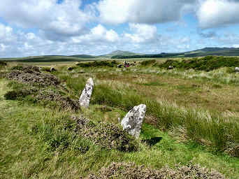
In early April 2006, having finished walking Mark Camp's Copper Trail, I went back to Five Lanes to investigate an area that I had looked at briefly on the trail and that had attracted me when studying the Ordnance Survey map. This lies just off the Copper Trail, to the south of Five Lanes and the A30 highway. In a fairly complex walk I took a lane through Tregirls and up onto the moor at Eastmoorgate, having checked first that East Moor is an unrestricted Open Access area. Once on the moor I headed up 1100 foot Fox Tor - great views in all directions - where there are traces of a boundary bank and the outlines of former long houses. Then westwards to find what had been a massive boundary bank and on to the south-east up another hill for a stone row and a couple of degraded cairns. South then for the Greymare Rock (not really an antiquity) and hut circles on Carey Tor. Finally northeast to find the Nine Stones circle. My one failure was that I could not find a line of Altarnun parish boundary stones, though I had previously found one near Clitters on a Copper Trail walk. A great walk and fascinating, if mostly rather rudimentary, remains. Afterwards I enjoyed another great, and good value, beef and onion baguette at the King's Head at Five Lanes.
Full directions for a similar walk at Bodmin Moor Walks, Walk A30 05
On Ordnance Survey Explorer sheet 109.
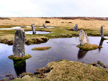
Part of Nine Stones Circle on East Moor
In January 2009 I walked again in this area. This time I succeeded in finding the boundary stones which mark the moorland boundary between the parishes of Altarnun and North Hill. How I missed them before I shall never know; they head clearly in two directions from Nine Stones Circle. For more on the boundary stones and on Clitters Hill see below
Fox Tor, Nine Stones and
More in Antiquities

Fox Tor, Nine Stones and Clitters Hill
Clitters Hill
King Arthur's Hall - On OS109 at grid ref: 12963/77623
This is a very puzzling site. There is a rectangular enclosure bank, over six feet high in places and some 160 feet by 65 feet. The inside is lined with apparently random stones, upright, angled or lying flat. Romantics would have us believe that the enclosure was once roofed, hence its name, but its sheer size makes that most unlikely. Its age is a puzzle; its existence was first recorded in 1584 when it was apparently already known as King Arthur’s Hall. According to Craig Weatherhill, in his Cornovia, it could date from the Neolithic period, as do similar enclosures in Ireland and Wales. Some have suggested that it could simply be a cattle enclosure but its interior wetness makes that unlikely. It is noticeable that inside the bank and stones is a well defined rectangle of mares tail grass, inside that a rectangle of cotton grass. This suggests a lining of some sort that holds the moisture. Could it just be that it was a man-made pond or even reservoir to water the cattle on the moor or provide a water source for settlements nearby. Whatever its purpose, the sheer size suggests a place of some importance. It still feels like a special place, perhaps because of its location. Despite nearby farms and villages, you feel total isolation on the high moorland, your views of the higher land of Garrow Tor, Rough Tor and Brown Willy only heightening that feeling.
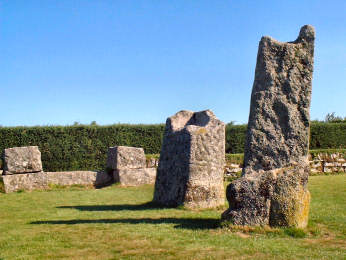
King Doniert's Stones
In a nicely maintained granite-walled enclosure, on the minor road between Doublebois and Minions, are a couple of granite standing stones, with handy car parking by the site. It is unclear whether they were always two or whether they are one broken in two. You will find it impossible to read the inscription carved in the granite but a plaque nearby carries the information: 'King Doniert's Stone. Men Myghtern Doniert. These two granite cross bases (if they are indeed separate) are decorated in the late Ninth Century style and probably date from that time. The shorter stone carries a Latin inscription "Doniert Progant Pro Anima", saying "Doniert ordered [this cross] for [the good of] his soul". Doniert was probably Durngarth, King of Cornwall who was drowned in AD875. The two stones have rectangular sockets on their top and probably carried wooden crosses'. Durngarth apparently drowned in the River Fowey near Draynes Bridge (a mile west), possibly at scenic Golitha Falls, reviewed on my 'Countryside' pages. Other sites to visit around Minions include Trethevy Quoit, the Hurlers and Pipers stones and Stowe's Hill. It is also well worth following a quiet signposted footpath along the old mineral tramway south towards the village of Crow's Nest to find the gaunt ruins of South Caradon Mine and the pleasant Crow's Nest Inn, where we have enjoyed many a hot baguette.