Porthleven
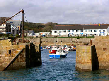
Porthleven is an attractive small town on Cornwall's south coast, three miles to the south-west of Helston. The long narrow harbour is a haven to both fishermen and yachtsmen. It is overlooked on its west side by an attractive pub, the Ship, and on its east side by Bay View, a long curving and very handsome row of Victorian homes, and the clock tower of the Institute, familiar from storm pictures. Since we first encountered Porthleven things have changed a great deal. We remember it as being a bit dreary and with almost no activity out of the summer holiday season. Now it seems to be full of second homes, many of them new but reasonably in character, and many of the former fisherman's cottages are now holiday rentals. Indeed, along the east side of the harbour, and up Cliff Road towards Loe Bar, restorations and new builds are almost all second homes or holiday rentals. Eating places in town have improved in response to this change and there are now many more of them. Latest addition is a fish and chip shop, opened in 2007 by a chatty incomer from Newcastle. In 2008 we enjoyed a meal from Roland's Happy Plaice, eaten sitting on the harbour wall. A pleasant short walk to the south-east takes you to remarkable Loe Bar. An attractive and enjoyable place but, like many harbour villages, this gets very busy in summer. A Rick Stein restaurant on the west side has now closed permanently. Round Walk from Helston.
Porthleven harbour
Signed by B3304 from A394 west of Helston
East and West
More in Towns & Villages
Porthoustock and Porthallow
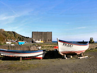
Jane and I were fascinated by Porthoustock when we visited a few years ago. Now I have been back I am even more taken with the place. I was there in November 2005 in the course of a walk that took in St. Keverne, Porthoustock, Porthkerris and Porthallow. While on Porthoustock beach I had a long chat with retired fisherman Roy Curnow and learned a lot about the locality. Four miles of coast here is riddled with stone quarries and it is they which have very much determined the character of Porthoustock, Porthkerris and Porthallow. Beaches have been formed by longshore drift of dark quarry spoil; that at Porthoustock rose gradually by eight feet when a massive groyne was built with a stone hopper on it to load ships. Former winch huts are now used for storage, a tractor draws boats up the beach. An earth mover maintains the height of the beach. Most cottages were once quarrymens homes; some are still lived in by descendants who make a small living from the sea but many are now second homes. There is a lovely thatched terrace just up the valley. West of England quarry still operates but St. Keverne quarry closed in 1958. Until the 1970s two cotils, small steep south facing fields were used to grow early potatoes, harvested in March or April. Porthallow, too, is now largely second home territory. Its claim to fame is as the halfway point on the South West Coath Path.
Portloe
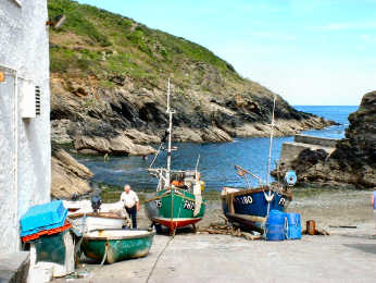
Portloe, on the south coast between Gorran Haven and Portscatho, is expensive territory - inhabited largely by wealthy second home owners - and no wonder. It is a total delight. To get the best out of just driving through, approach from the east so the steep narrow hill down gives you an overview of the tiny fishing cove. Leave westwards towards Veryan. But you will never do Portloe justice by merely driving through. Instead, approaching from the east, park in the only car park, way up the hill. Walk its narrow street and enjoy the charming cottages, with a couple of exceptions no longer fishermen's cottages. Wander down to the cove where you will see evidence of the crab and lobster still caught by the fishermen. The buildings on the cove are mostly part of the Lugger Hotel, one of Cornwall's best. Get an expensive but good lunch here (they do have a car park) or walk up the Veryan road for a pub lunch in the ancient Ship Inn. If you are slightly adventurous, and properly shod, you can enjoy a delightful view from the coast path in either direction. To the east, walk between the Lugger and its car park, follow the cove, take some steps down, cross a tiny stream and the slipway of the former Lifeboat Station ( now a home with a view) and you will come up onto the coast path. Continue a little way and you will come to an amazing shack that was once the Coastguard lookout. Great views from here.
Portreath
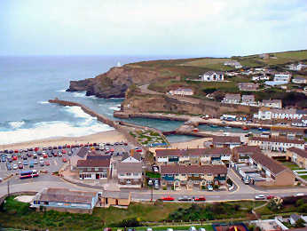
Jane remembers Portreath from wartime when her father used to explain why the village was closed. When we visited in 2003, I was taken by the long narrow harbour, almost unused, and by postwar housing occupying a level V-shaped section between harbour and cliffs. Portreath is now a very ordinary down-market little resort, blessed by a safe sandy family beach but I wanted to find out something of its history. It turns out that it was an 18th and 19th century port, a major player in the tin and copper trade, serving mines around Redruth and Camborne. An important tramway ran from Redruth and is now part of the Coast-to-Coast Mining Trail. A steep inclined plane also ran down from the western side. The port declined in the 20th century and the harbour is now used by a small fishing fleet and by pleasure boats. In World War II Portreath changed beyond recognition. The military took over, clearing away warehouses, and the port served a top secret airfield and weapons storage facility high on the east side at Nancekuke. The warehousing area now has late 20th century housing on it, most of it frankly quite unattractive, while chalets line the cliffs. The airfield remains closed and teams still search for unspecified but apparently deadly hidden weaponry. Below, Portreath's Industrial History