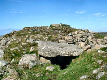
Chapel Carn Brea Bronze Age Tomb
Brea Bronze Age Tomb
Even if you have no interest in antiquities, this is a spot that is well worth visiting for its location and views. Chapel Carn Brea - not to be confused with Carn Brea at Camborne/Redruth, is Cornwall's most westerly hill. Although rising only to 650 feet, the panorama is quite stupendous. Below you spreads a patchwork of small fields, the settlement of St. Just, and Land's End and both coasts. You may see, as I did, planes flying into tiny Land's End airfield. To the southeast you can see Lizard Point, 21 miles away; to the west you can see Longships Lighthouse off Land's End; to the southwest you may see the Isles of Scilly, some 31 miles distant. If you are interested in antiquities and history, what you will find at the very top of the hill is a Bronze Age chambered cairn, a vast burial mound covered with rocks. It is very badly disturbed and degraded; a medieval hermitage was built here, using stones from the cairn and, in the second world war, a radar station was built on it. Fairly nearby is another odd feature, close by a rocky tor, which none of the authorities I have consulted mention but which I think is an earlier neolithic long barrow. There is also a charred area where local pagans burn midsummer bonfires. The hill is fairly steep but easy to climb. There is a car park at its foot from which you can also walk to Carn Euny iron age village by way of St. Euny's Well.
Chapel Carn Brea cairn; is it a cist on south side?
Car park on road from Crows an Wra to Land's End airfield
More in Antiquities

Chysauster Iron Age Village
Where Carn Euny has only been partially excavated, Chysauster (its name is actually 'Chy Sylvestra', meaning the houses in the wood) has been more fully excavated since its discovery in around 1860, much the same time as Carn Euny. Unlike earlier Carn Euny, Chysauster dates from around the birth of Christ and was occupied during the Roman period. Being later, it is more sophisticated, consisting of nine courtyard houses, mostly fairly fully excavated. As you can see from the photograph, its substantial walls rise to around eight feet. The houses are known as 'courtyard houses' because the four or five rooms, backed by massive stone walls, surround an open courtyard. They are entered by a long entrance passage, believed to have been gated, giving a good degree of privacy. In the centre of the main room, a stone in the floor has a hole where a timber would have supported a thatched roof. In evidence are hearths, corn-grinding stones and covered sewers. Each of the houses appears to have had its own terraced garden. The fogou, unlike that at Carn Euny, is in a ruinous state and is not open. The site is in the care of English Heritage so there is a small entrance fee. The walk from the car park to the site is a gentle climb of about quarter of a mile. There is a small shop in the reception hut but no refreshments.

Ch�n Castle and Ch�n Quoit
Ch�n Castle and the nearby Ch�n Quoit neolithic burial chamber are among Cornwall's least accessible ancient monuments. Footpaths to the site are not signed and you will need to find Trehyllys Farm (please ask the farmer's permission to park) near Great Bosullow, a mile off the Penzance to Morvah road. It is worth it; the ragged ruins of Ch�n Castle suggest the former size of this iron age fort. Almost 200 feet in diameter, its tumbled walls must have been six feet thick - and in 1951 Jacquetta Hawkes recorded that, in living memory, its walls had stood twelve feet high. She believed it to have been connected with the tin trade. While you will need to use considerable imagination, this is an impressively dominant site, which must have been much like an Irish rath and similar to Staigue Fort in Ireland's County Kerry. Use OS Explorer Sheet 102, whether coming by car or in the course of a hike. You could include a visit to nearby Men-an-Tol stones.
CORNISH ANCIENT SITES PROTECTION NETWORK
ANCIENT SITES PROTECTION NETWORK